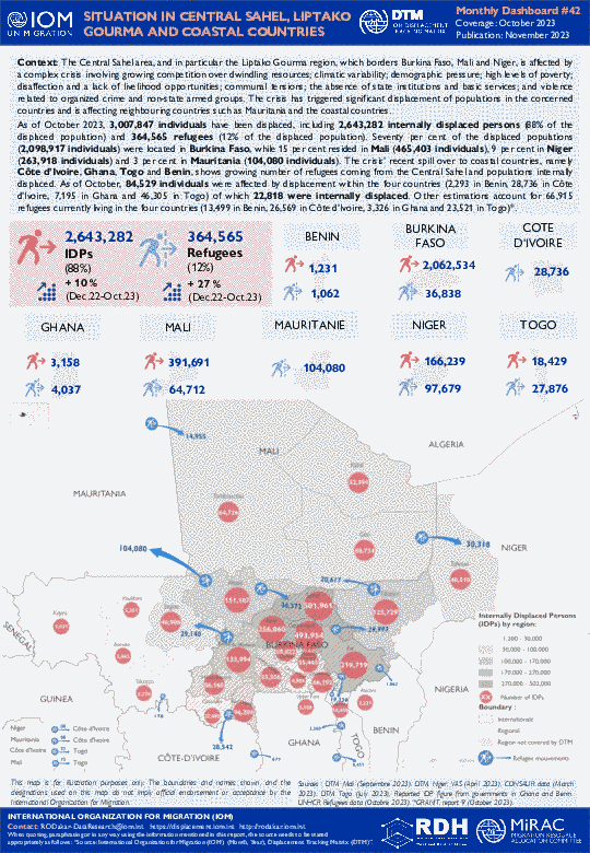
The Central Sahel area, and in particular the Liptako Gourma region, which borders Burkina Faso, Mali and Niger, is affected by a complex crisis involving growing competition over dwindling resources; climatic variability; demographic pressure; high levels of poverty; disaffection and a lack of livelihood opportunities; communal tensions; the absence of state institutions and basic services; and violence related to organized crime and non-state armed groups. The crisis has triggered significant displacement of populations in the concerned countries and is affecting neighbouring countries such as Mauritania and the coastal countries.
As of October 2023, 3,007,847 individuals have been displaced, including 2,643,282 internally displaced persons (88% of the displaced population) and 364,565 refugees (12% of the displaced population). Seventy per cent of the displaced populations (2,098,917 individuals) were located in Burkina Faso, while 15 per cent resided in Mali (465,403 individuals), 9 per cent in Niger (263,918 individuals) and 3 per cent in Mauritania (104,080 individuals). The crisis’ recent spill over to coastal countries, namely Côte d’Ivoire, Ghana, Togo and Benin, shows growing number of refugees coming from the Central Sahel and populations internally displaced. As of October, 84,529 individuals were affected by displacement within the four countries (2,293 in Benin, 28,736 in Côte d’Ivoire, 7,195 in Ghana and 46,305 in Togo) of which 22,818 were internally displaced. Other estimations account for 66,915 refugees currently living in the four countries (13,499 in Benin, 26,569 in Côte d’Ivoire, 3,326 in Ghana and 23,521 in Togo)*.
- Mobility Tracking
- Site Assessment
- Village Assessment
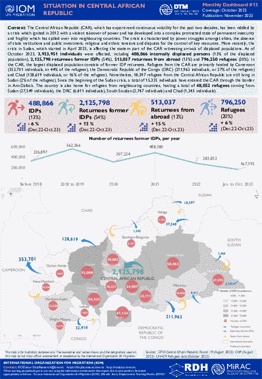
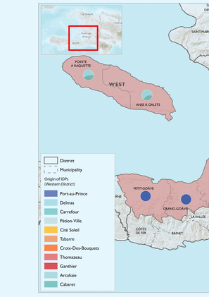
The Central African Republic (CAR), which has experienced continuous volatility for the past two decades, has been riddled by a crisis which ignited in 2012 with a violent takeover of power and has developed into a complex protracted state of permanent insecurity and fragility which has spilled over into neighbouring countries. The crisis is characterized by power struggles amongst elites, the absence of state institutions and public investment, religious and ethnic tensions and disputes for the control of key resources. More recently, the crisis in Sudan, which started in April 2023, is affecting the eastern part of the CAR witnessing arrivals of displaced populations. As of October 2023, 3,923,951 individuals were affected, including 488,866 internally displaced persons (13% of the displaced population), 2,125,798 returnees former IDPs (54%), 513,037 returnees from abroad (13%) and 796,250 refugees (20%). In the CAR, the largest displaced population consists of former IDP returnees. Refugees from the CAR are primarily hosted by Cameroon (353,701 individuals, or 44% of the refugees), the Democratic Republic of the Congo (DRC) (211,963 individuals, or 27% of the refugees) and Chad (128,619 individuals, or 16% of the refugees). Nonetheless, 18,597 refugees from the Central African Republic are still living in Sudan (2% of the refugees). Since the beginning of the Sudan crisis, a total of 15,335 individuals have entered the CAR through the border in Am-Dafock. The country is also home for refugees from neighbouring countries, hosting a total of 48,052 refugees coming from Sudan (37,549 individuals), the DRC (6,411 individuals), South Soudan (2,747 individuals) and Chad (1,345 individuals).